Property history for U 1/220-226 Princes Highway, Kogarah Bay NSW 2217
All Sold Rent
This property has no listed sales or rental history.
This property has no listed sales history.
This property has no listed rental history.
About this property
U 1/220-226 Princes Highway, Kogarah Bay NSW 2217
| Bedrooms | 1 |
| Bathrooms | 1 |
| Car Spaces | 1 |
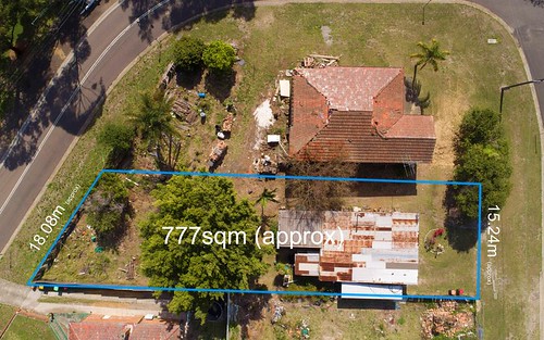
| Land Size | 1171 m2 |
| Building Area | n/a |
| Property Type | Unit |
| Council Area | Unavailable |
| Year Built | n/a |
| Lot/Plan | n/a |
| Suburb Name | Kogarah Bay |
| Postcode | 2217 |
| State | NSW |
Comparable Sold properties in Kogarah Bay
Looking at similar homes in Kogarah Bay, NSW 2217 can help you better understand this unit's potential value.


Comparable Rent properties in Kogarah Bay
Looking at similar homes in Kogarah Bay, NSW 2217 can help you better understand this unit's potential value.


Schools closest to U 1/220-226 Princes Highway, Kogarah Bay NSW 2217
| School name | Address | Type | Sector | Distance |
|---|---|---|---|---|
| Carlton South Public School | JUBILEE AVECarlton 2218 | Primary | Government | 0.82 km |
| Blakehurst Public School | DEWRANG STBlakehurst 2221 | Primary | Government | 0.88 km |
| Blakehurst High School | WONIORA RDBlakehurst 2221 | Secondary | Government | 0.88 km |
| St Raphael's Catholic Primary School | 82 GEORGE STREETSouth Hurstville 2221 | Primary | Catholic | 1.17 km |
| St George Christian SchoolTop 100 | 55-67 WOIDS AVENUEHurstville 2220 | Combined | Independent | 1.3 km |
| Mater Dei Catholic Primary School | 29 HEATH ROADBlakehurst 2221 | Primary | Catholic | 1.3 km |
| St Finbar's Primary School | Sans Souci 2219 | Primary | Catholic | 1.61 km |
| Carlton Public School | CAMERON STBexley 2207 | Primary | Government | 1.72 km |
| Bexley North Public School | KINGSLAND RDBexley 2207 | Primary | Government | 1.77 km |
| Bexley Public School | FOREST RDBexley 2207 | Primary | Government | 1.77 km |
Neighbouring properties to U 1/220-226 Princes Highway, Kogarah Bay NSW 2217
Explore other properties on Kogarah Bay, NSW 2217.
Suburb Information
Kogarah Bay, NSW 2217
Part of Kogarah
14.04 km
Distance from Sydney CBD
21 k
Population
$2.3M
Median House Price
$915K
Median Unit Price