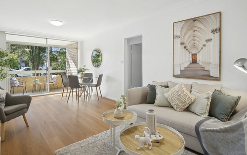
Property history for 120 Burns Bay Road, Lane Cove NSW 2066
All Sold Rent
Nov 2016
$540 per week- Rent
- L J Hooker Lane Cove
Nov 2000
$260,000- Sold
Sep 1999
$291,000- Sold
About this property
120 Burns Bay Road, Lane Cove NSW 2066
| Bedrooms | 2 |
| Bathrooms | 1 |
| Car Spaces | 1 |
| Land Size | 2503 m2 |
| Building Area | n/a |
| Property Type | unit |
| Council Area | Lane Cove |
| Year Built | 2008 |
| Lot/Plan | SP7647 |
| Suburb Name | Lane Cove |
| Postcode | 2066 |
| State | NSW |
Comparable Sold properties in Lane Cove
Looking at similar homes in Lane Cove, NSW 2066 can help you better understand this unit's potential value.
Comparable Rent properties in Lane Cove
Looking at similar homes in Lane Cove, NSW 2066 can help you better understand this unit's potential value.
Schools closest to 120 Burns Bay Road, Lane Cove NSW 2066
| School name | Address | Type | Sector | Distance |
|---|---|---|---|---|
| Lane Cove Public School | AUSTIN ST & LONGUEVILLE RDLane Cove 2066 | Primary | Government | 0.87 km |
| Lane Cove West Public School | AVALON AVELane Cove 2066 | Primary | Government | 0.92 km |
| St Michael's Catholic Primary School | 181-187 LONGUEVILLE ROADLane Cove 2066 | Primary | Catholic | 1.03 km |
| St Ignatius' CollegeTop 100 | TAMBOURINE BAY ROADLane Cove 2066 | Combined | Independent | 1.63 km |
| Chatswood High SchoolTop 100 | CENTENNIAL AVEChatswood 2067 | Secondary | Government | 2.13 km |
| Hunters Hill High School | REIBY RDHunters Hill 2110 | Secondary | Government | 2.34 km |
| Chatswood Public SchoolTop 20 | CENTENNIAL AVEChatswood 2067 | Primary | Government | 2.36 km |
Neighbouring properties to 120 Burns Bay Road, Lane Cove NSW 2066
Explore other properties on Lane Cove, NSW 2066.
Suburb Information
Lane Cove, NSW 2066
Part of Lane Cove
7.45 km
Distance from Sydney CBD
26 k
Population
$2.99M
Median House Price
$943K
Median Unit Price
Auction Results For Lane Cove
Units sold in Last 12 months ends 4 Jan 2025
$905K
Median Sale Price
75%
Clearance Rate
162/217
Sold/Reported
$3.26M
Highest Sale Price
| Sold Price Range | No. of Sold Properties | |
|---|---|---|
| $3 M and more | 1 | |
| $2 M - $3 M | 2 | |
| $1.8 M - $2 M | 3 | |
| $1.6 M - $1.8 M | 5 | |
| $1.4 M - $1.6 M | 5 | |
| $1.2 M - $1.4 M | 5 | |
| $1 M - $1.2 M | 13 | |
| $800 K - $1 M (Median Price Range) | 33 | |
| $600 K - $800 K | 19 | |
| $400 K - $600 K | 1 | |


