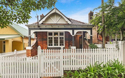
Property history for 21 Slade Street, Naremburn NSW 2065
All Sold Rent
May 2019
$1,850,000- Sold
- McGrath - Crows Nest
Oct 2017
$840 per week- Rent
- McGrath Crows Nest
Mar 2017
$830 per week- Rent
- McGrath Crows Nest
Aug 2014
$820 per week- Rent
- McGrath - Lane Cove
May 2014
$1,325,000- Sold
Apr 2012
$770 per week- Rent
- Eps Property Search Neutral Bay
Aug 2010
$750 per week- Rent
- Eps Property Search Neutral Bay
Sep 2009
$660 per week- Rent
- Eps Property Search Neutral Bay
Jun 2008
$925,000- Sold
Apr 2008
$925,000- Sold
- First National Willoughby
Apr 2008
$795,000- Sold
- LJ Hooker - Willoughby
Nov 2006
$540 per week- Rent
Mar 2004
$870,000- Sold
Oct 2001
$610,000- Sold
- Asset Realty
Sep 1997
$451,000- Sold
Jun 1991
$250,000- Sold
Jan 1989
$220,000- Sold
About this property
21 Slade Street, Naremburn NSW 2065
| Bedrooms | 2 |
| Bathrooms | 1 |
| Car Spaces | 2 |
| Land Size | 342 m2 |
| Building Area | 90 m2 |
| Property Type | house |
| Council Area | Willoughby |
| Year Built | 1920 |
| Lot/Plan | 2/DP522416 |
| Suburb Name | Naremburn |
| Postcode | 2065 |
| State | NSW |
Comparable Sold properties in Naremburn
Looking at similar homes in Naremburn, NSW 2065 can help you better understand this unit's potential value.
Comparable Rent properties in Naremburn
Looking at similar homes in Naremburn, NSW 2065 can help you better understand this unit's potential value.
Schools closest to 21 Slade Street, Naremburn NSW 2065
| School name | Address | Type | Sector | Distance |
|---|---|---|---|---|
| Naremburn School | WILLOUGHBY RDNaremburn 2065 | Combined | Government | 0.44 km |
| Cammeray Public SchoolTop 50 | PALMER STCammeray 2062 | Primary | Government | 0.78 km |
| Cammeraygal High School | Crows Nest 2065 | Secondary | Government | 1.04 km |
| St Philip Neri Catholic Primary SchoolTop 50 | 67 BARINGA ROADNorthbridge 2063 | Primary | Catholic | 1.11 km |
| North Sydney Boys High SchoolTop 5 | FALCON STREETCrows Nest 2065 | Secondary | Government | 1.44 km |
| North Sydney Girls High SchoolTop 5 | PACIFIC HWYCrows Nest 2065 | Secondary | Government | 1.51 km |
| Willoughby Girls High SchoolTop 50 | MOWBRAY RDWilloughby 2068 | Secondary | Government | 1.6 km |
| Bradfield College | PACIFIC HIGHWAYCrows Nest 2065 | Secondary | Government | 1.66 km |
| Marist College North Shore | 270 MILLER STREETNorth Sydney 2060 | Secondary | Catholic | 1.66 km |
| Willoughby Public School | OAKVILLE ROADWilloughby 2068 | Primary | Government | 1.68 km |
Neighbouring properties to 21 Slade Street, Naremburn NSW 2065
Explore other properties on Naremburn, NSW 2065.
Suburb Information
Naremburn, NSW 2065
Part of Willoughby
6.29 km
Distance from Sydney CBD
25 k
Population
$2.86M
Median House Price
$1.3M
Median Unit Price
Auction Results For Naremburn
Houses sold in Last 12 months ends 11 Jan 2025
$2.86M
Median Sale Price
96%
Clearance Rate
23/24
Sold/Reported
$4.13M
Highest Sale Price
| Sold Price Range | No. of Sold Properties | |
|---|---|---|
| $3 M and more | 3 | |
| $2 M - $3 M (Median Price Range) | 7 | |


