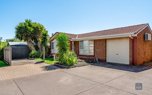
Property history for 6-8 Sherriff Street, Underdale SA 5032
All Sold Rent
Feb 2008
N/A- Sold
Jun 2005
$245 per week- Rent
May 2005
$545,000- Sold
About this property
6-8 Sherriff Street, Underdale SA 5032
| Bedrooms | 3 |
| Bathrooms | 1 |
| Car Spaces | 0 |
| Land Size | 2109 m2 |
| Building Area | 109 m2 |
| Property Type | unit |
| Council Area | West Torrens |
| Year Built | 1946 |
| Lot/Plan | 19/F122813 |
| Suburb Name | Underdale |
| Postcode | 5032 |
| State | SA |
Comparable Sold properties in Underdale
Looking at similar homes in Underdale, SA 5032 can help you better understand this unit's potential value.
Comparable Rent properties in Underdale
Looking at similar homes in Underdale, SA 5032 can help you better understand this unit's potential value.
Schools closest to 6-8 Sherriff Street, Underdale SA 5032
| School name | Address | Type | Sector | Distance |
|---|---|---|---|---|
| St John Bosco School | 19 LIPSETT TCEBrooklyn Park 5032 | Primary | Catholic | 0.64 km |
| Torrensville Primary School | HAYWARD AVENUETorrensville 5031 | Primary | Government | 0.69 km |
| Underdale High School | GARDEN TERRACEUnderdale 5032 | Secondary | Government | 0.79 km |
| Flinders Park Primary School | HOLBROOKS ROADFlinders Park 5025 | Primary | Government | 1.43 km |
| Cowandilla Primary School | JENKINS STREETCowandilla 5033 | Primary | Government | 1.41 km |
| Lockleys North Primary School | MALURUS AVENUELockleys 5032 | Primary | Government | 1.26 km |
| Lockleys Primary School | ELSTON STREETBrooklyn Park 5032 | Primary | Government | 1.6 km |
| Tenison Woods Catholic Primary School | 68 BROOKER TCERichmond 5033 | Primary | Catholic | 2.01 km |
| St Joseph's School | 39 BERTIE STWest Hindmarsh 5007 | Primary | Catholic | 2.48 km |
| Warriappendi School | JOHN STREETMarleston 5033 | Secondary | Government | 2.77 km |
Neighbouring properties to 6-8 Sherriff Street, Underdale SA 5032
Explore other properties on Underdale, SA 5032.
Suburb Information
Underdale, SA 5032
Part of West Torrens
4.73 km
Distance from Adelaide CBD
11 k
Population
$836K
Median House Price
$358K
Median Unit Price


