


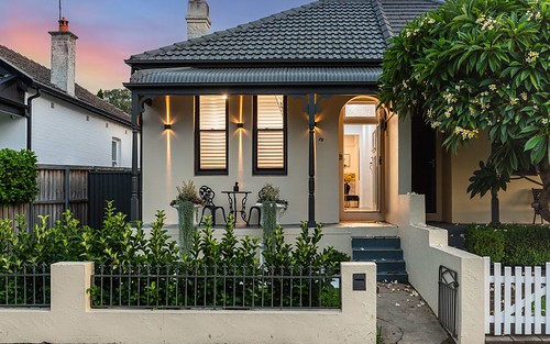
Property history for 9 Lucy Street, Ashfield NSW 2131
All Sold Rent
Feb 2022
$1,800,000- Sold
- Cobden & Hayson - Annandale
Feb 2022
N/A- Sold
- Cobden & Hayson - Annandale
Jun 2014
$921,000- Sold
- Belle Property - Newtown
Jun 2010
$580 per week- Rent
- L J Hooker Maroubra
Nov 2009
$633,000- Sold
- LJ Hooker - Ashfield
Nov 2007
$400 per week- Rent
- L J Hooker Ashfield
About this property
9 Lucy Street, Ashfield NSW 2131
| Bedrooms | 2 |
| Bathrooms | 2 |
| Car Spaces | 1 |
| Land Size | 323 m2 |
| Building Area | 100 m2 |
| Property Type | house |
| Council Area | Inner West |
| Year Built | 1920 |
| Lot/Plan | D/442865 |
| Suburb Name | Ashfield |
| Postcode | 2131 |
| State | NSW |
Comparable Sold properties in Ashfield
Looking at similar homes in Ashfield, NSW 2131 can help you better understand this unit's potential value.


Comparable Rent properties in Ashfield
Looking at similar homes in Ashfield, NSW 2131 can help you better understand this unit's potential value.


Schools closest to 9 Lucy Street, Ashfield NSW 2131
| School name | Address | Type | Sector | Distance |
|---|---|---|---|---|
| De La Salle College | 24 BLAND STAshfield 2131 | Secondary | Catholic | 0.66 km |
| Bethlehem College | 18 BLAND STREETAshfield 2131 | Secondary | Catholic | 0.71 km |
| St Vincent's Catholic Primary School | 30-34 CHARLOTTE STREETAshfield 2131 | Primary | Catholic | 0.78 km |
| Presbyterian Ladies CollegeTop 20 | BOUNDARY STREETCroydon 2132 | Combined | Independent | 0.78 km |
| Croydon Public School | YOUNG STCroydon 2132 | Primary | Government | 0.81 km |
| Rosebank College | 1A HARRIS ROADFive Dock 2046 | Secondary | Independent | 0.98 km |
| Haberfield Public School | DENMAN AVEHaberfield 2045 | Primary | Government | 0.96 km |
| Burwood Girls High School | QUEEN STREETCroydon 2132 | Secondary | Government | 1.06 km |
| Holy Innocents' Catholic Primary School | 86-98 QUEEN STREETCroydon 2132 | Primary | Catholic | 1.06 km |
| Ashfield Public School | LIVERPOOL RDAshfield 2131 | Primary | Government | 1.26 km |
Neighbouring properties to 9 Lucy Street, Ashfield NSW 2131
Explore other properties on Ashfield, NSW 2131.
Suburb Information
Ashfield, NSW 2131
Part of Ashfield
7.69 km
Distance from Sydney CBD
22 k
Population
$1.89M
Median House Price
$740K
Median Unit Price
Auction Results For Ashfield
Houses sold in Last 12 months ends 28 Sep 2024
$2.16M
Median Sale Price
84%
Clearance Rate
35/42
Sold/Reported
$3.45M
Highest Sale Price
| Sold Price Range | No. of Sold Properties | |
|---|---|---|
| $3 M and more | 3 | |
| $2 M - $3 M (Median Price Range) | 16 | |
| $1.8 M - $2 M | 7 | |
| $1.6 M - $1.8 M | 1 | |