


Property history for 4/16-20 Laurence Avenue, Airport West VIC 3042
All Sold Rent
Feb 2017
$470,000- Sold
- Barry Plant - Keilor East
Apr 2008
$285,000- Sold
- Real Estate Edge - Essendon
Mar 2008
$285,000- Sold
- Raine And Horne Essendon
Sep 2007
$4,280- Sold
May 2006
$125,000- Sold
Oct 2002
$90,000- Sold
Jan 2001
$143,000- Sold
Oct 1998
$115,000- Sold
- EJ Doherty
Apr 1993
$102,800- Sold
Aug 1985
$66,000- Sold
Dec 1983
$45,640- Sold
Jan 1979
$33,500- Sold
Dec 1977
$34,000- Sold
This property has no listed rental history.
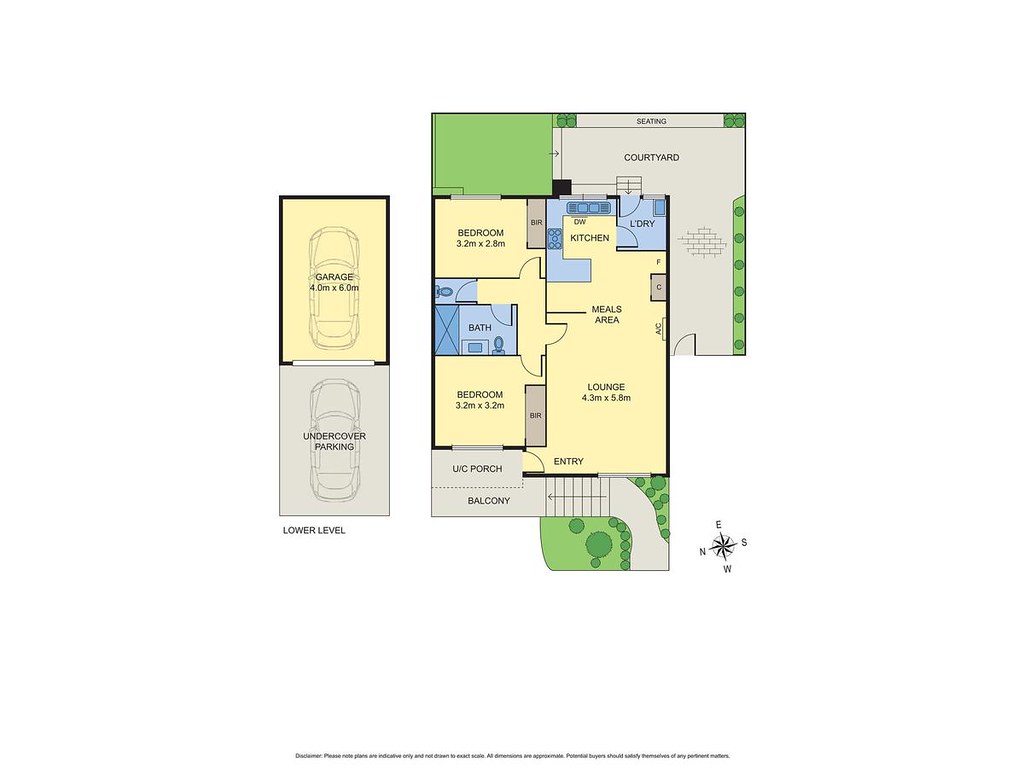
About this property
4/16-20 Laurence Avenue, Airport West VIC 3042
| Bedrooms | 2 |
| Bathrooms | 1 |
| Car Spaces | 1 |
| Land Size | 5233 m2 |
| Building Area | 87 m2 |
| Property Type | unit |
| Council Area | n/a |
| Year Built | 1977 |
| Lot/Plan | n/a |
| Suburb Name | Airport West |
| Postcode | 3042 |
| State | VIC |
Comparable Sold properties in Airport West
Looking at similar homes in Airport West, VIC 3042 can help you better understand this unit's potential value.


Comparable Rent properties in Airport West
Looking at similar homes in Airport West, VIC 3042 can help you better understand this unit's potential value.


Schools closest to 4/16-20 Laurence Avenue, Airport West VIC 3042
| School name | Address | Type | Sector | Distance |
|---|---|---|---|---|
| Essendon East Keilor District College Niddrie Campus | Niddrie 3042 | Secondary | Government | 0.18 km |
| Niddrie Primary School | 25 WATT STREETNiddrie 3042 | Primary | Government | 0.26 km |
| St Christopher's School | 34 ROBERTS RDAirport West 3042 | Primary | Catholic | 0.47 km |
| Penleigh & Essendon Grammar School | 163 RACHELLE RDKeilor East 3033 | Combined | Independent | 0.84 km |
| Keilor Heights Primary School | RONALD GROVEKeilor East 3033 | Primary | Government | 1.41 km |
| St John Bosco's School | 29 MURIEL STNiddrie 3042 | Primary | Catholic | 1.94 km |
| Rosehill Secondary College | SAPPHIRE STREETNiddrie 3042 | Secondary | Government | 2.19 km |
| St Peter's School | 2A PARKSIDE AVEKeilor East 3033 | Primary | Catholic | 2.42 km |
| Buckley Park College | COOPER STREETEssendon 3040 | Secondary | Government | 2.69 km |
Neighbouring properties to 4/16-20 Laurence Avenue, Airport West VIC 3042
Explore other properties on Airport West, VIC 3042.
Suburb Information
Airport West, VIC 3042
Part of Moonee Valley
13.16 km
Distance from Melbourne CBD
14 k
Population
$965K
Median House Price
$645K
Median Unit Price
Auction Results For Airport West
Units sold in Last 12 months ends 28 Sep 2024
$685K
Median Sale Price
66%
Clearance Rate
38/58
Sold/Reported
$1.24M
Highest Sale Price
| Sold Price Range | No. of Sold Properties | |
|---|---|---|
| $1.2 M - $1.4 M | 1 | |
| $1 M - $1.2 M | 1 | |
| $800 K - $1 M | 8 | |
| $600 K - $800 K (Median Price Range) | 20 | |
| $400 K - $600 K | 3 | |