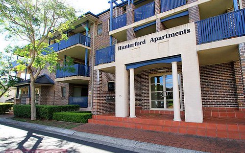
Property history for 7/38 York Street, Oatlands NSW 2117
All Sold Rent
Sep 2016
$655,000- Sold
- Pam Easson Real Estate
Oct 2012
$400 per week- Rent
- Pam Easson Real Estate - Oatlands
Jan 2010
$390,100- Sold
- Century 21 Property Central - Carlingford
Oct 2009
$380 per week- Rent
- Pam Easson Real Estate - Oatlands
Aug 2009
$655,000- Sold
- Century 21 Property Central - Carlingford
Aug 2009
$390,100- Sold
- Century 21 Property Central - Carlingford
Jun 2005
$382,000- Sold
- Peter Shipway Realty A1 Mine Settlement
Jun 2002
$340,000- Sold
- Shire Real Estate Agents
Jul 1993
$180,000- Sold
About this property
7/38 York Street, Oatlands NSW 2117
| Bedrooms | 2 |
| Bathrooms | 1 |
| Car Spaces | 2 |
| Land Size | 6467 m2 |
| Building Area | n/a |
| Property Type | unit |
| Council Area | Parramatta |
| Year Built | 1992 |
| Lot/Plan | 7/SP42709 |
| Suburb Name | Oatlands |
| Postcode | 2117 |
| State | NSW |
Comparable Sold properties in Oatlands
Looking at similar homes in Oatlands, NSW 2117 can help you better understand this unit's potential value.
Comparable Rent properties in Oatlands
Looking at similar homes in Oatlands, NSW 2117 can help you better understand this unit's potential value.
Schools closest to 7/38 York Street, Oatlands NSW 2117
| School name | Address | Type | Sector | Distance |
|---|---|---|---|---|
| Cumberland High School | PENNANT HILLS ROADCarlingford 2118 | Secondary | Government | 0.81 km |
| The King's SchoolTop 50 | PENNANT HILLS ROADNorth Parramatta 2151 | Combined | Independent | 1.12 km |
| Oatlands Public School | BELMORE ST EASTOatlands 2117 | Primary | Government | 1.36 km |
| RIDBC Garfield Barwick School | 106 PENNANT HILLS ROADNorth Parramatta 2151 | Combined | Independent | 1.28 km |
| Burnside Public School | MASONS DRIVENorth Parramatta 2151 | Primary | Government | 1.28 km |
| James Ruse Agricultural High SchoolTop 5 | FELTON RDCarlingford 2118 | Secondary | Government | 1.42 km |
| Telopea Public School | CHESTNUT AVENUETelopea 2117 | Primary | Government | 1.38 km |
| Redeemer Baptist School | 2-12 MASONS DRIVENorth Parramatta 2151 | Combined | Independent | 1.32 km |
| Dundas Public School | KISSING POINT ROADDundas 2117 | Primary | Government | 1.69 km |
| Tara Anglican School for GirlsTop 50 | MASONS DRIVENorth Parramatta 2151 | Combined | Independent | 1.46 km |
Neighbouring properties to 7/38 York Street, Oatlands NSW 2117
Explore other properties on Oatlands, NSW 2117.
Suburb Information
Oatlands, NSW 2117
Part of The Hills Shire
18.76 km
Distance from Sydney CBD
19 k
Population
$2.36M
Median House Price
$978K
Median Unit Price
Auction Results For Oatlands
Units sold in Last 12 months ends 4 Jan 2025
$1.47M
Median Sale Price
84%
Clearance Rate
5/6
Sold/Reported
$1.61M
Highest Sale Price
| Sold Price Range | No. of Sold Properties | |
|---|---|---|
| $1.6 M - $1.8 M | 1 | |
| $1.4 M - $1.6 M (Median Price Range) | 2 | |
| $1.2 M - $1.4 M | 1 | |
| $1 M - $1.2 M | 1 | |


